How to reduce denial, redesign, and delay before you commit to plans
If your home is in or near a FEMA-mapped flood zone in Barnstable (or elsewhere on Cape Cod), “Can we add on?” quickly turns into “What will the town allow, what will FEMA/State code require, and will the historic district commission approve the exterior changes?” This guide breaks down the most common Cape Cod flood zone addition requirements so you can plan with clear expectations—especially if your property is in a historic district (including areas associated with Old King’s Highway) or a coastal flood hazard area.
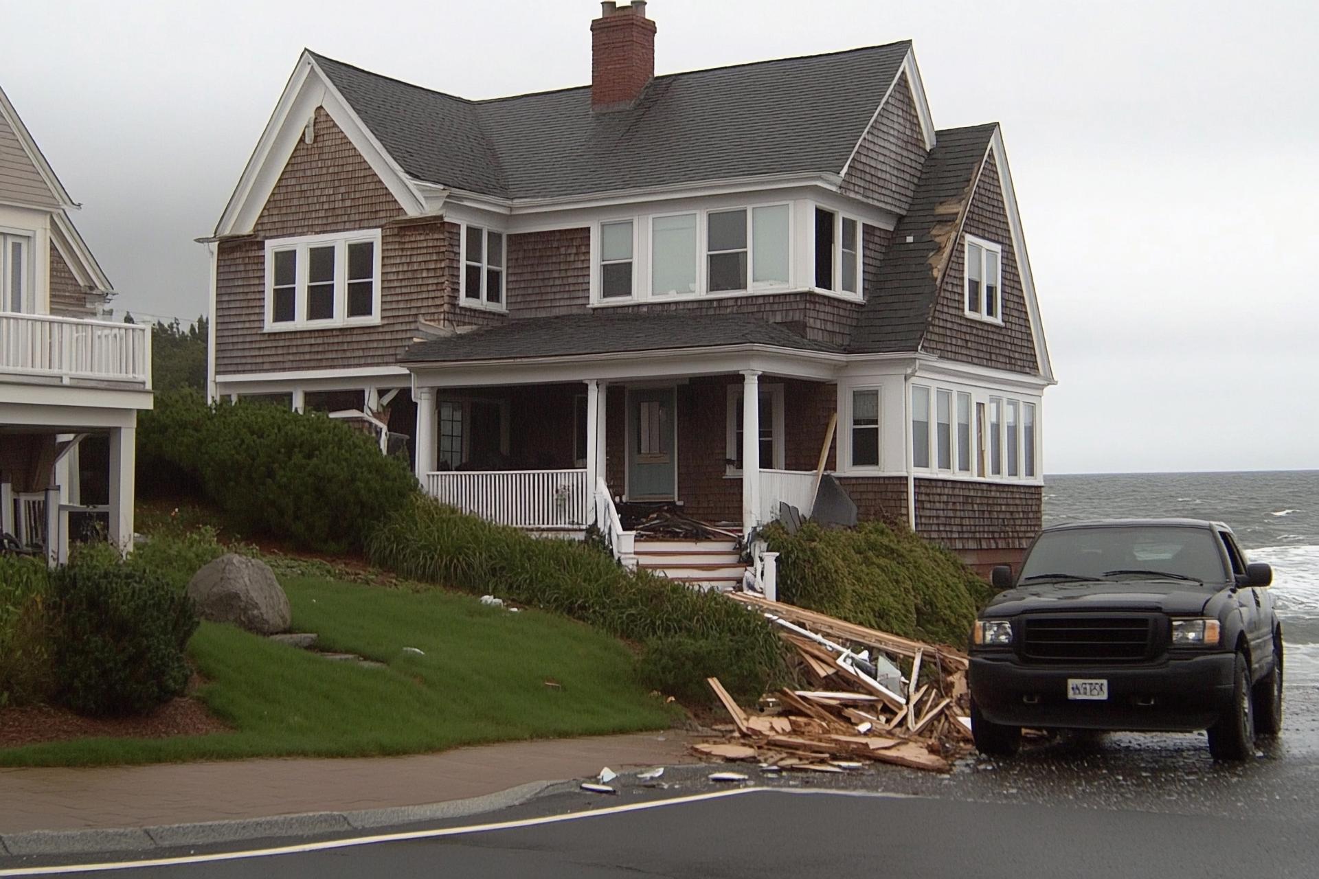
The core issue: additions can trigger full flood-compliance (not just “the new part”)
The biggest surprise for risk-averse homeowners is that a seemingly straightforward addition can trigger a “substantial improvement” determination—often called the 50% rule. In FEMA Special Flood Hazard Areas (zones that start with A or V), when improvement costs reach or exceed 50% of the structure’s market value, the structure may need to be brought into compliance with current flood regulations. That can mean elevating the building/foundation approach, reworking utilities, and making material and enclosure choices that are very different from typical inland remodeling.
For historic properties, there can be specific exemptions around substantial improvement requirements—but they’re narrow, fact-specific, and should be confirmed early so your design direction doesn’t get reset midstream.
What “flood zone requirements” usually include on Cape Cod
While your exact requirements depend on your mapped zone (A/AE vs. coastal high-hazard V) and your site’s Base Flood Elevation (BFE), Massachusetts code and common municipal enforcement focus on a few consistent themes:
Barnstable’s overlay district reality: expect a permit path, documentation, and elevation records
In Barnstable, floodplain development is not treated like “ordinary remodeling.” The Town’s Floodplain Overlay District framework requires permits for development activities and specifically calls for review and recordkeeping around elevation and floodproofing levels for new construction or substantial improvements. In other words: plan for an administrative process, not just a contractor schedule.
A helpful mental model
Think of your project as three overlapping approvals that must agree with each other: (1) zoning & local floodplain rules, (2) state building code for flood-resistant construction, and (3) exterior/design review if you’re in a historic district or under an HDC.
Old King’s Highway & historic review: why “what looks right” must also be “what’s allowed”
The Old King’s Highway corridor is part of a regional historic district created to preserve the historic character of the route across multiple Cape towns. If your home falls under a historic district commission (HDC) review, massing, rooflines, windows, siding, trim details, and additions’ visibility from the public way can strongly influence what gets approved.
The key planning tension is this: flood compliance may push you toward elevation changes and foundation strategies, while historic review may push you toward traditional proportions and exterior character. That’s solvable—but it’s best solved early, before detailed construction drawings are complete.
Quick comparison: what tends to change by zone type
| Planning Item | A/AE Zones (riverine/coastal flooding) | V Zone (Coastal High Hazard) / Coastal A (wave action A zone) |
|---|---|---|
| Elevation target | Often BFE plus a required margin (freeboard) based on adopted code/standard | Typically stricter; focus on the lowest horizontal structural member elevation |
| Floodproofing approach | Wet/dry floodproofing rules vary by occupancy and elevation requirements | Dry floodproofing is generally not permitted; wave forces drive design choices |
| Utilities | Often must be elevated above required levels | Usually even more restrictive; plan early for equipment locations |
| Substantial improvement risk | High—project costs can trigger full compliance | High—plus structural/wave considerations can increase scope |
Note: This table is intentionally simplified. Your actual requirements depend on your FEMA panel, BFE, the town’s adopted freeboard, and your project classification under Massachusetts code and local bylaws.
Step-by-step: a low-regret way to plan a flood-zone addition
1) Confirm your mapped zone, BFE, and whether you’re in a floodplain overlay district
Start with the facts that will drive everything: zone type (A/AE/V), the base flood elevation, and whether the town treats your parcel as part of its Floodplain Overlay District. In Barnstable, permits and elevation recordkeeping are explicitly part of the process.
2) Screen your concept for “substantial improvement” risk early
Before you fall in love with a design, do a rough budget and compare it to the structure’s market value basis used for substantial improvement determinations. If you’re close to the threshold, you’ll want to plan for the possibility that the addition triggers broader flood compliance requirements.
3) Decide which “path” you’re on: modest addition vs. elevation/major rework
Many Cape Cod projects naturally separate into two lanes: (a) a smaller scope that stays below substantial improvement, or (b) a bigger reconfiguration that treats elevation and flood compliance as part of the project’s value. The right choice depends on long-term use, insurance, comfort, and how you want the home to live.
4) If historic review applies, align exterior choices with flood requirements
If your home is subject to historic district review, assume the exterior will be scrutinized: roof pitch, window proportions, addition placement, and how foundation/elevation changes read from the street. The Old King’s Highway regional district exists specifically to preserve character, so your addition should look intentional—not like a code workaround.
5) Plan utilities and storage realistically (and early)
Flood-resilient homes often require relocating or rethinking mechanicals, electrical panels, and storage assumptions. Massachusetts flood provisions reference ASCE standards and include elevation expectations for utilities and equipment.
6) Use design visualization to reduce re-draws and “late surprises”
For flood-zone and historic-district projects, a 3D design approach can help you evaluate height, massing, and exterior proportions before you invest heavily in construction documentation—especially when inches matter for elevations and sightlines.
Local Barnstable angle: why early coordination matters more here
Barnstable homeowners often face overlapping constraints: coastal exposure, FEMA mapping, town overlay requirements, and (in some neighborhoods) design oversight tied to historic character. The win is not “finding loopholes”—it’s building a realistic plan that satisfies permitting, protects the home, and still looks like it belongs on Cape Cod.
A pre-consultation checklist to bring to your first meeting
Want clarity before you hire an architect or finalize plans?
Capizzi Home Improvement has helped Cape Cod and South Shore homeowners plan and build remodeling projects since 1976. If you’re in a flood zone, a historic district, or both, an early conversation can help you identify constraints, avoid redesign loops, and move forward with confidence.
FAQ: Cape Cod flood zone additions (Barnstable-focused)
Does a small addition always trigger FEMA’s “50% rule”?
No. The trigger is tied to the cost of improvements relative to the market value of the structure (not the land) and whether you’re in a Special Flood Hazard Area. Your local floodplain administrator makes the determination based on adopted rules and documentation.
If we cross the threshold, do we have to bring the entire house into compliance?
Often, yes—crossing “substantial improvement” can require broader compliance, not just the new portion. That’s why early scope/budget screening is so important in flood zones.
Are historic homes exempt from substantial improvement requirements?
There can be exemptions for certain historic structures where flood-compliance work would jeopardize the continued historic designation. Eligibility is specific to the structure and the proposed work, so it should be verified early with the appropriate authorities.
What permits should we expect in Barnstable for floodplain work?
Barnstable’s Floodplain Overlay District framework anticipates permits for development activity and includes review/recordkeeping related to elevation and floodproofing for substantial improvements and new construction. Your exact permit list depends on the scope and site conditions.
Do flood zone rules affect basements and storage?
Frequently, yes. Flood-resistant design standards can limit below-grade spaces, require specific enclosure strategies, and push mechanical/storage decisions upward. The exact constraints depend on your zone type and required elevations.
Educational note: This content is general guidance for early planning. Floodplain determinations and historic reviews are project-specific—confirm your requirements with the Town of Barnstable and qualified design/build professionals.